AT_CORE_SETTING_BAR

Showcases

Background Image

AT_CORE_SETTING_DESC

tz_map

Country Fact Sheet

Capital: Dodoma  Area: 947,303 km2

Population: 44 Million (2012 Census)

Life Expectancy: Male 60, Female 64 years

Total Forested Land

48 Million Ha Equivalent to

54.4% of Total Land Area of

88.3 Million Hectares

Wood Demand & Supply

Consumption: 62.3 Million m3/year

Supply: 42.8 Million m3/year

Deficit: 19.5 Million m3/year

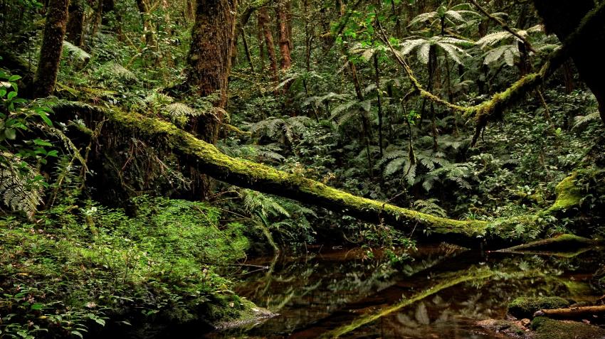
Montane Moist Forest in the Nguru mountains, central Tanzania: Photo Credit Francesco Rovero

Forests in Tanzania play an important role in the daily livelihoods. They are an important source of energy for cooking, building timber, traditional medicine, tourism, fodder, water catchments, shelter for wildlife and estuaries for fish breeding areas. Furthermore, these forests also have high biodiversity, containing over 10,000 plant species, hundreds of which are nationally endemic, 724 species of flora and fauna identified as threatened in the IUCN Red List, and 276 species of flora and fauna classified as endangered (IUCN, 2013).

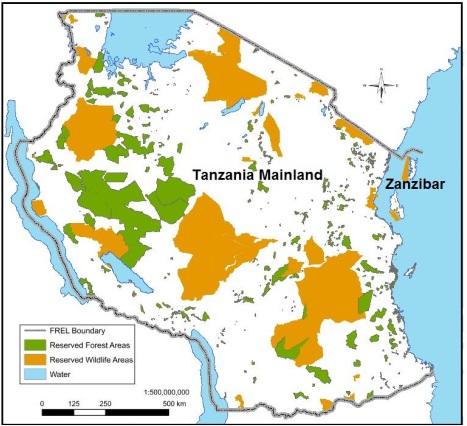
Reserved areas in Tanzania (Mainland and Zanzibar) include Conservation Areas, namely, National Parks, Game Reserves, and Nature Forest Reserves (Protective); and Forest Reserves (Protected and Production). These nature forest reserves and forest reserves are managed by either the Central Government or the Local Government Authorities. The reserved area occupies almost 50% of the forested area in Tanzania. These reserved areas are legally protected, and therefore, it is possible to reverse the current forest losses with interventions.

Protected Areas

Ecosystem Types

Ecosystem type

Main regions

Acacia savanna

Shinyanga, Singida

Coastal forest

Lindi, Mtwara, Pwani

Eastern Arc/montane forest

Iringa, Morogoro, Tanga

Guinea-Congo

Kagera, Mwanza

Miombo woodland

Manyara, Morogoro, Tabora

Miombo woodland

Iringa, Morogoro, Tabora


Forest Definition

‘Forest’ means an area of land with at least 0.5 ha, with a minimum tree crown cover of 10% or with existing tree species planted or natural having the potential of attaining more than 10% crown cover, and with trees which have the potential or have reached a minimum height of 3m at maturity in situ.

Drivers of Deforestation and Degradation

Who is Monitoring

Monitored by Ministry of Agriculture, Ministry of Planning, Economy and Empowerment (Monitoring of National Strategy for Growth and Reduction of Poverty – NSGRP, also known as MKUKUTA)

How is it Monitored

  • Crop productivity aggregated at four governance levels: village, district, regional and national
  • Shifting arable land with changes in temperature and precipitation as detailed in the National Investment Centre (NIC) and NAPA documents
  • Changes in cropping patterns (mono-crop vs. mixed) farming, timing (earlier or later), crop types, seed varietiesfertilizers, pesticides and herbicides
  • Percentage change in food crop production Ministry of Agriculture and Food Security (MAFS)
  • Percentage of smallholders using modern methods of farming (irrigation, fertilizers and improved seeds) National Bureau of Statistics (NBS)
  • Percentage of households whose main income is derivfrom harvesting, processing and marketing of natural resources products National Bureau of Statistics (NBS) or Ministry of Natural Resources and
  • Percentage of smallholders who have one or more off-farm income generating activities National Burea of Statistics
  • Percentage of smallholders who accessed formal credits for agricultural purpose (NBS)

Who is Monitoring

Tanzania Forest Services and National Bureau of Statistics HBS/National Census

How is it Monitored

  • Revenues from sale of forest products
  • Information related to illegal activities and changes in forest utilization
  • Percentage change in proportion of rural households reliance on forest products
  • Adoption of alternative livelihood activities

Who is Monitoring

Ministry of Planning, Economy and Empowerment, Ministry of Energy and Tanzania Forest Service

How is it Monitored

  • Percentage increase in number of customers connected to the national grid and off-grid sources of electricity Ministry of Energy and Minerals (MEM), National/Stations
  • Percentage of households in rural and urban areas using alternative sources of energy to wood fuel (including charcoal) as their main source for cooking NBS
  • Energy generation capacity by source (hydro, wind, solar, gas)
  • Percentage of population connected to the national grid
  • National energy generation capacity
  • Number of projects/programs on alternative energy sources
  • Proportion of households dependent on forests for energy resources

Who is Monitoring

Tanzania Forest Service

How is it Monitored

  • Hectares of land under forest fire annually

Roads generally result in increased deforestation and degradation (Nepstad et al. 2001). They make the transport of goods possible and economically viable, linking resources and producers to markets at lower costs

A large proportion of the population depends on forests in some way for their livelihoods or for their fuelwood, this consequently puts pressure on forests and land


Source: Adapted from Excellensia Consulting (2010)

Total Forest Cover

Trends in forest change from 1990 to 2010 showing an average loss of 403,328 ha per year


Total Forested Land

Forests include

  • Montane
  • Lowland
  • Mangrove
  • Plantation Forest

Woodland include

  • Open and Closed Woodlands
  • Thickets

 Woodlands occupy 93% of total forested land

Forest Ownership

Tanzania National Indicators

Tanzania Forest Main Institutions

  • EEFCCC.jpg
  • kfs.jpg
  • mzq.png
  • nfa.jpg
  • tfs.png
Powered by Amazing-Templates.com 2014 - All Rights Reserved.