AT_CORE_SETTING_BAR

Showcases

Background Image

AT_CORE_SETTING_DESC

tz_map

Country Fact Sheet

Capital: Maputo  Area: 801,590 km2

Population: 24 Million (2014 Estimate)

Life Expectancy: Male 50, Female 52 years

Total Forested Land

41 Million Ha Equivalent to

51.4% of Total Land Area of

77.9 Million Hectares

Wildfires 2013 Statistics

Land Affected: 10.9 million ha

Active Fires : 90,000 wildfire hotspots

Province Mostly Affected : Niassa

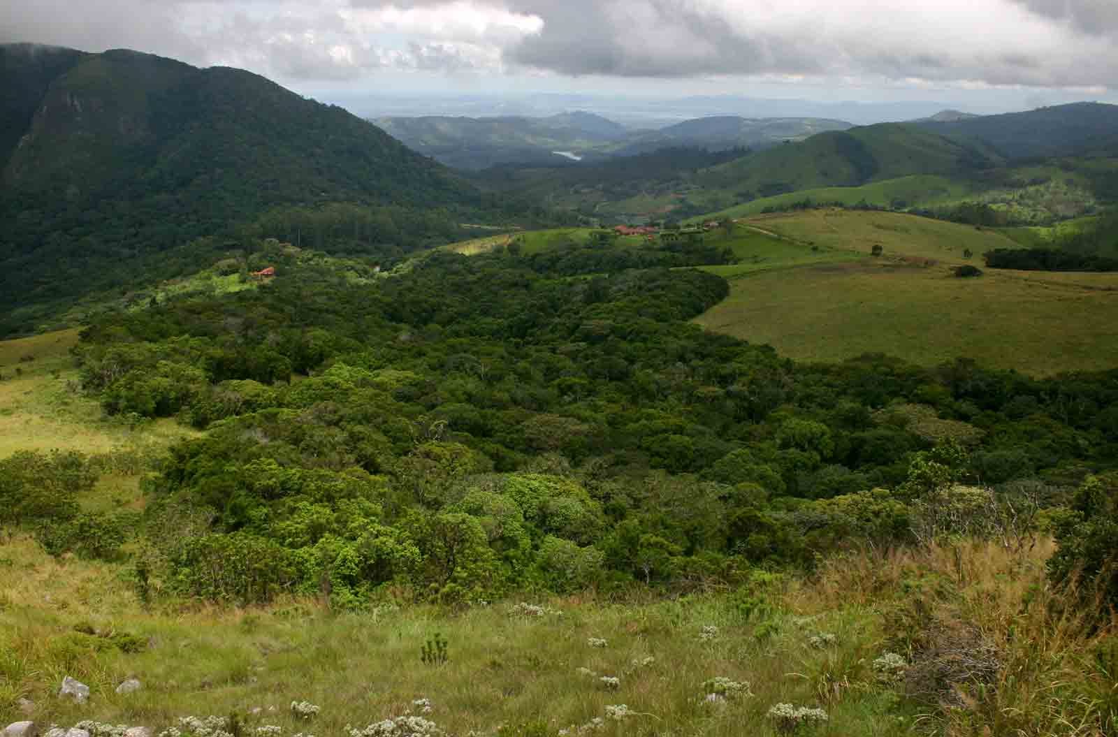
Cloudlands Forest taken from the summit of Chinziwa: Photo Credit BT Wursten

In Mozambique, the exploitation of forest resources is governed by the Policy and of Forests and Wildlife Development Strategy, Forestry and Wildlife Law 10/99 and its Regulation approved by Decree 12/2002 of June 6, which resulted from a participatory process. The forests in Mozambique are managed by National Directorate of Forestry in the ministry of Ministry of Land, Environment and Rural Development (MITADER).

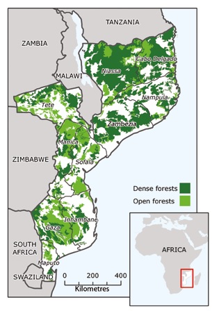
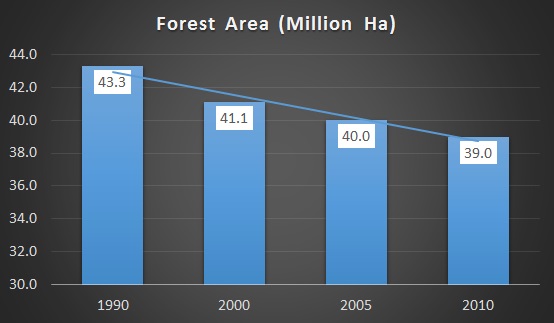
Mozambique still has a large forest cover with forests of different densities and composition, occupying an area equivalent to 70% of the total area of the country and the commercial value being exploited at a level of about 515.7 to 640.5 thousand m3 per year. The area covered with forests is estimated at 40.1 million hectares (51%), of which 26.9 million are suitable for the production of commercially valuable timber, and 13.2 million hectares are conservation areas. The country Global Forest Resources Assessment was conducted in 2010 (FRA 2010). 

Unknown Mozambique Forest Found Through Google Earth

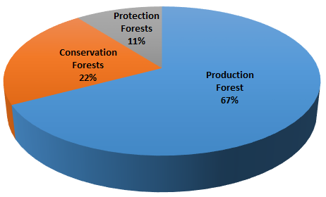
As the main custodian and owner of all national forests, the government manages and allocates forests to other stakeholders. Local communities can lease portions of the forest estate if they are registered according to the laws. Forests in Mozambique are divided into three types of forests: conservation forests, production forests and protection forests.

The country has ongoing programmes that contribute to Establishment of a REDD+ system in Mozambique, these include; developing a forest resource information platform, developing an infrastructure for measurement, reporting, and verification (MRV) using that platform, forming Reference Emissions Levels or Reference Levels (REL/RL) for deforestation and forest degradation, and development data sets for estimation of forest biomass and carbon volumes. Also the country is implementing regular and appropriate monitoring systems of forest resources. Other ongoing country activities include; developing National Forestry strategy, National Forest Safeguards; study in drivers of deforestation and degradation, and Strategic Environmental and Social Assessment (SESA) under REDD+.

MITADER has adopted several strategic actions to address challenges in the forest sector including; a participatory audit of all forest concessions, the suspension of new requests for exploration areas, a ban on log exports, the updating of forest policies and regulations, and an ambitious project called “Floresta em Pé”, which aims to promote sustainable integrated rural development though protection, conservation, valorization, creation and sustainable management of forests.

Map of Forest Cover 2007

Ecosystem Types

Ecosystem type

Provinces

Mopane Forest


Gaza, Tete, Northern of Sofala &

Manica Province

Mecrusse Forest

Inhambane, Gaza, Nampula & Sofala

Mountainous Forest

Zambezia, Mania & Niassa

Mangoves Forest

Along the wetlands of Coastal Area


Forest Definition

A forest is an area of at least 1 ha with a tree crown cover of 30%, with trees that reach more than 5 m

Drivers of Deforestation and Degradation

Agents and Indirect Causes

  • Increased demand for agricultural products (tobacco, cotton, soybeans)
  • Infrastructure expanding
  • Political factors

Main degradation activities

  • Selective wood cutting
  • Firewood collection
  • Hunting
  • Pastures
  • Fires

Main deforestation activities

  • Large-scale production of sugarcane. producing vegetables, corn, soybeans, bananas
  • Small scale agriculture in a Outgrowing-system cotton, cashew, tobacco

Results

  • Deforestation for establishing the commercial agriculture and forest degradation

Agents and Indirect Causes

  • Population Growth
  • Increased domestic Demand for agricultural product
  • Technological Development

Main degradation activities

  • Selective wood cutting
  • Firewood collection
  • Hunting
  • Pastures
  • Fires

Main deforestation activities

  • Shifting cultivation
  • Yield crops
  • Residential Areas

Results

  • Deforestation for itinerant agriculture and Forest Degradation

Agents and Indirect Causes

  • The increasing international demand for wood and its derivatives
  • Political factors and governance
  • Population growth

Main degradation activities

  • Illegal logging
  • Firewood collection
  • Selective cutting

Main deforestation activities

  • Forest concessions (native wood)
  • Forest Plantations

Results

  • Deforestation for or extraction of timber and products derivates and Forest Degradation

Agents and Indirect Causes

  • Population Growth
  • Infrastructure expansion
  • Increased energy needs

Main degradation activities

  • Firewood collection
  • Coal Production
  • Collection

Main deforestation activities

  • Firewood collection and unsustainable charcoal production
  • Expansion of housing and infrastructure areas

Results

  • Deforestation by accumulation of impact over time collecting firewood and charcoal production and Forest Degradation

Agents and Indirect Causes

  • Population Growth
  • Economic Factors
  • Migration urban rural areas
  • Tourism
  • Political Factors

Main degradation activities

Main deforestation activities

  • Infrastructure expansion (eg roads, housing, tourist accommodation)
  • Industry expanding

Results

  • Deforestation for establishing urban Forest Degradation

Agents and Indirect Causes

  • Increasing international demands for minerals
  • Job search/migration

Main degradation activities

Main deforestation activities

  • Mineral extraction
  • Settlements in residential areas
  • Infrastructure for exploration and flow

Results

  • Deforestation related to mineral extraction Forest Degradation

Agents and Indirect Causes

  • Standard increase in the local population consumption
  • Animal products for domestic consumption
  • Technological Development

Main degradation activities

  • Pastures of small scale and in wooded areas
  • Firewood Production
  • Hunting
  • Fires

Main deforestation activities

  • Extensive grazing of cattle

Results

  • Deforestation r elated to the creation of cattle, goats, swine, birds and Forest Degradation

Total Forest Cover

Between 1990 and 2010 Mozambique lost 10.0% of its forest cover, around 4,356,000 ha, whereby the average loss per year is 217,800 ha.


Carbon Stocks

Forest classification based on usage

  • Production Forests: 26.9 million ha
  • Conservation Forests: 8.9 million ha
  • Protection Forests: 4.2 million ha

Mozambique National Indicators

Powered by Amazing-Templates.com 2014 - All Rights Reserved.