AT_CORE_SETTING_BAR

Showcases

Background Image

AT_CORE_SETTING_DESC

Country Fact Sheet

Capital: Nairobi Area: 581,309 km2

Population: 48 Million (2015 estimation)

Life Expectancy: Male 57, Female 59 years

Total Forested Land

3.5 Million Ha Equivalent to

6.9% of Total Land Area of

56.9 Million Hectares

Wood Demand & Supply

Consumption: 41.7 Million m3/year

Supply: 31.4 Million m3/year

Deficit: 10.3 Million m3/year

Thrill of a 3km of zip-lining adventure at Kereita Forest. Photo Credit btito.com

About 7% of Kenya’s total land area is forest. These forests provide goods and services such as wildlife habitat, biological diversity, water catchment, employment opportunities and livelihood sources. Forests and trees play multiple functions in contributing to the livelihoods of communities, especially women and marginal groups, in supplying food and rural energy.However, these forests are threatened with agricultural expansion, over-exploitation and unsustainable use of forest resources; population increase and widespread youth unemployment have led to increased pressure on forest resources.

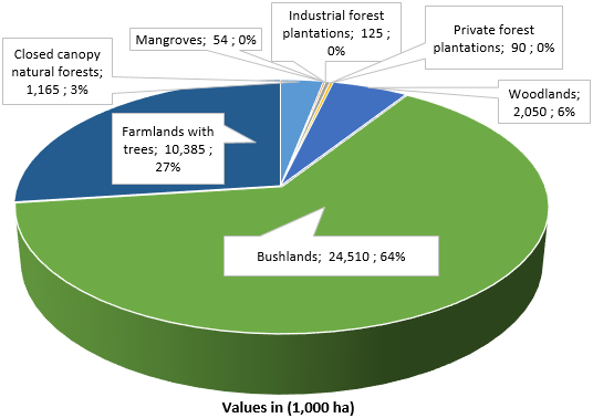
According to the last inventory undertaken in 2010 (KFS, 2013a), forests in Kenya occupy 6.99% of the land area. These forests are categorised as Montane, Western rain forest, Bamboo, Afro-montane undifferentiated forest, Coastal and Dryland forests. The montane forest and the coastal forest regions are the most forested with 18% and 10% forest cover, respectively.  Natural forests in Kenya are made up of montane forests, which occupy about 2% of the total land area (1.14 million hectares). A considerable area of 2.13 million hectares consists of bush land and mangroves. Public and private plantations constitute 220,000 hectares (FAO, 2015d).

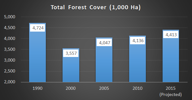
Analysis of change in forest cover over the last 25 years revealed improved afforestation activities. Forest land has decreased by 311,000 ha while crop land increased by 1,018,000 ha between 1990 and 2015. Between 1990 and 2000, Kenya lost approximately 1.2 million ha of forest land, equivalent to 25% of forest cover. However, there is a remarkable increase in forest cover from 6.01% in 2000 to the predicted 7.46% in 2015. This is equivalent to an annual increase of 0.1%. Most (77%) of the forest land in Kenya is under community and private ownership while 23% is public. Private plantations cover 47% of the total forest plantation area, which is almost equal to the area of stocked plantations under public management (53%).

Kenya has, a National Forest Programme 2016-2013 which was developed to increase forest cover, boost the forest sector’s contribution to the national economy, enhance resilience to climate change and improve livelihoods. This programme will significantly enhance not only sustainable forest management but also improve the coordination of various sectors.

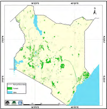
Distribution of Forests 2010

Ecosystem Types

Ecosystem type

Main regions

High mountains
and high ranges

Elgon, Kenya, Aberdares,
Cherangani and Mau

Western plateau

Kabarnet, Kakamega, Nandi
and Trans-Mara

Northern mountains

Ndotos, Mathews, Leroghi, Kulal
and Marsabit
a

Coastal forests:

Arabuko-Sokoke, Tana, Kayas,
coral rag and mangrove forests

Southern hills

Taita Hills, Kasigau, Shimba Hills,
Chyulu Hills and Nguruman

Riverine forests

Tana and tributaries, Ewaso-Ngiro,
Kerio, Turkwell and Galana

Forest Definition

Forest means a land area of more than 0.5 ha, tree crown cover of 10%, with trees of at least 2.5m height, which is not primarily under agricultural or other specific non-forest land use.

Drivers of Deforestation and Degradation

Direct Drivers

  • Inadequate application of basic silvicultural and ecological principles for forest management
  • Tragedy of the commons resulting in conflicts over natural resources

Indirect Drivers

  • Inadequate integration of the forest sector with other stakeholders
  • Unclear forest responsibilities and weak conflict-management capacity
  • Weak forest governance and institutions
  • Corruption, illegal logging, weak enforcement
  • Inadequate benefit sharing from forest resources
  • Diverse perceptions of importance of forests
  • Communal land tenure systems and their application
  • Lack of private ownership, unclear tenure and access to forest resources

Direct Drivers

  • Overgrazing and inadequate regulation of grazing in forest reserves and community lands

Indirect Drivers

  • More focus shifted to water towers, paying less attention to dryland woodlands, including the coastal and riparian forests

Direct Drivers

  • Clearing of forest for agriculture
  • Degradation of forest
  • Charcoal and fuel wood from unsustainable production
  • Infrastructure and urbanisation
  • Conversion of communal forest to agriculture
  • Mining within forest areas
  • Illegal logging

Indirect Drivers

  • Demand is higher than supply
  • Heavy bureaucracy and poor efficiency obstructing competitiveness
  • Limited knowledge of tree growing (and necessary silviculture) as an enterprise
  • Poverty, high prices for agriculture products, subsidised fertiliser, tax exemption for certain agricultural machinery resulting in unhealthy competition for land
  • Fixed timber prices at low levels
  • Rapidly increasing population has heightened the demand for land
  • Few or no livelihood options have created over dependence on agriculture and mounting pressure on forest lands

Direct Drivers

  • Poor uptake of new technologies
  • Poor awareness of deforestation impacts
  • Poor knowledge of tree planting

Indirect Drivers

  • Uncertain availability of timber and wood for processing enterprises
  • Low investment in wood processing resulting in ineffective processing

Direct Drivers

  • Unsustainable utilisation, including overgrazing
  • Conflict at multiple levels
  • Fires are deliber ate, accidental, poorly managed and they destroy forests
  • Wildlife damage impacting regeneration

Indirect Drivers

  • Traditional farming methods in a context of increased population and overstocking of animals


Source: National Forest Programme 2016 - 2030

Total Forest Cover

Between 1990 and 2000, Kenya lost approximately 1.2 million ha of forest land, equivalent to 25% of forest cover.


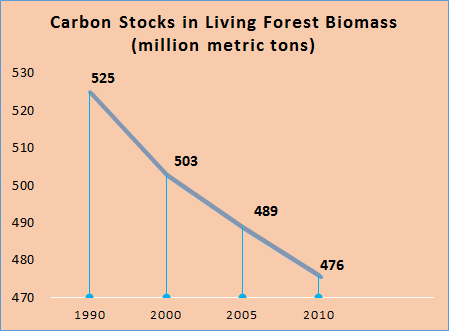
Carbon Stocks

Forest Estates

Kenya National Indicators

Kenya Forest Main Institutions

  • EEFCCC.jpg
  • kfs.jpg
  • mzq.png
  • nfa.jpg
  • tfs.png
Powered by Amazing-Templates.com 2014 - All Rights Reserved.